WhatsApp, Viber
+977-9851168665
 31 Mar, 2018
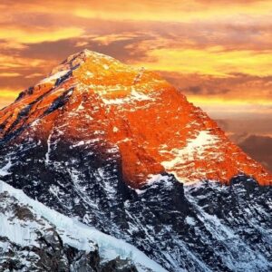
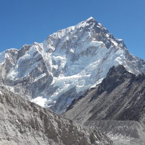
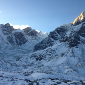
Upper Dolpo region is situated in the upper part of the Dolpo region in western Nepal, bordered to the north by China. It is surrounded by the Dhaulagiri and Churen Himal ranges and to the west by Jumla district. This region is known for its amazing flora and fauna, and the views along the trekking trails are stunning. Upper Dolpo is divided into four valleys: Tsharka Valley, Tarap Valley, Panzang Valley, and Nangkhong Valley, each with its own preserved cultural histories. The region offers a chance to immerse yourself in the unique surroundings of Dolpo. One of the main attractions, Shey Phoksundo National Park, lies at the center of Dolpo. You can also explore spectacular snowy peaks, enchanting rivers and lakes, ancient and remote villages, beautiful Buddhist monasteries, and endangered wildlife like Blue Sheep, Himalayan Black Bear, Snow Leopard, and Red Panda in the beautiful forests of blue pines and rhododendron.
Dolpo was an independent, economically and culturally rich region. In 1789, it was incorporated into the nation-state by the Gorkha tribes. Prithvi Narayan Shah consolidated power after conquering neighboring areas, and in 1769 he captured Kathmandu. By 1789, the Gorkhalis extended their territory over the Kali Gandaki Valley and the beautiful Kingdom of Lo, also known as Dolpo.
The trek leads to the restricted regions of Dolpa district, bordered by Tibet in the northeast, Jumla and Mugu in the west, Jajarkot and Rukum in the south, and Mustang in the east. It is the beautiful land of Bon - Po faith in western Tibet, under the shadow of the Dhaulagiri and Churen Himal ranges, providing excellent snowy views.
The trek starts in Kathmandu with a flight to Nepalgunj, where you can enjoy views of western Nepal. From Nepalgunj, another flight takes you to Jumla, and the trek begins from Gothichaur, covering an area of 2700m. The trek continues from Gothichaur to Napakhola, passing through small Buddhist settlements. The journey includes trekking from Ghotichaur to Napakhola, Napakhola to Chaurikot, Chaurikot to Bheri riverside, Bheri riverside to Gharpung Khola, Gharpung Khola to Kagmara, Kagmara to Kagmara Base Camp, Kagmara Base Camp to Cross Kagmara La, then to Pungma Khola, Pungma Khola to Pungmo Gaon, Pungmo Gaon to She Phoksundo Lake, Phoksundo to Bagala Base Camp, Bagala Base Camp to Cross Bagala Pass, Cross Bagala Pass to Numla Pass Base Camp, Numla Pass Base Camp to Chering Gompa, Chering Gompa to Do Tarap, Do Tarap to Lahini, Lahini to Tarakot, Tarakot to Dunai, and Dunai to Jhupal. The journey offers spectacular views of the Himalayas and the diverse flora and fauna of the region. The trek ends with a return flight from Jhupal to Nepalgunj and then back to Kathmandu, followed by an evening dinner and cultural program provided by the company.
After arriving in Kathmandu, the trek starts the next day with a flight to Nepalgunj, known for the Bhageswori temple. From Nepalgunj, a 45-minute flight takes you to Jhupal at 2320m, followed by a trek to Dunai, taking about 3 hours. The trek passes through deep gorges and streams, offering spectacular views of the mountain ranges and the daily lifestyle of people in Simikot village at 3000m. The trek continues from Dunai to Tarakot, Tarakot to Laini, Laini to Nawarpani, Nawarpani to Tarap, Tarap to Numa La Base Camp, Numa La Base Camp to Pelung Tang, Pelung Tang to Cross Baga La, Cross Baga La to Ringmo, Ringmo to Phoksundo, Phoksundo to Shyanta, Shyanta to Jhupal. The journey offers amazing moments, rich biological culture, and the ecosystem of the Dolpo region. The trek ends with a return flight from Jhupal to Nepalgunj and then back to Kathmandu, followed by an evening dinner and cultural program provided by the company. The next day will be your departure day or the start of another program if interested.
The National Tourism Board of Nepal designates different trekking trails under restricted trails, preserving regions with cultural and natural heritage. As a result, trekking to these regions requires special permits, with fees reflecting the significance of the area. For Upper Dolpo, permits cost $500 per person for the first 10 days, while Lower Dolpo costs $10 per person per week. Dolpo, known for its isolated and tranquil environment, is divided into Upper and Lower Dolpo regions. Upper Dolpo has a strong Tibetan influence, offering a unique opportunity to explore Tibetan culture, traditions, and norms. Lower Dolpo, on the other hand, features a mix of Buddhist and Hindu villages and cultures. Both regions provide a unique trekking experience with spectacular mountain views and untouched landscapes.
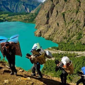
Phoksundo Lake, located in the Dolpo district, is a spectacular sight with its unique greenish-blue color. The lake is 5.15 km long, 800 m wide, and 145 m deep. It contains more than 20 stupas in the southern belt and various Gompas in the eastern part. According to ancient history, the lake was created by a female demon.
The Government of Nepal has declared some regions as restricted, requiring special permits for trekking. This is to protect and preserve the historical monuments and monasteries. For Upper Dolpo, the permit costs US$ 500 per person for the first 10 days and US$ 50 per person per day beyond 10 days. For Lower Dolpo, the permit costs US$ 10 per person per week. The country has open borders and connections with China and Tibet, so strict permit regulations are in place. At least two individuals are needed for the trek, or two permits must be issued if solo. Permits are also required for other restricted areas like Tsum Valley, Lark Pass Valley, Kanchenjunga, Upper Mustang, and Manaslu Circuit. A reliable trekking agency is necessary to process the permits and provide an additional individual.
For trekking in Upper or Lower Dolpo, a licensed guide is required due to the region's proximity to China and Tibet. According to Nepal's immigration law, at least one government-authorized person must accompany visitors to these restricted areas.
Nepal has four main seasons: summer, winter, autumn, and spring. The best seasons for trekking in Nepal are autumn, summer, and spring, offering excellent weather and magnificent views. Trekking in Upper and Lower Dolpo is ideal during these times, from March to November. The region can also be trekked during the monsoon season as it lies in the rain shadow of the Annapurna and Dhaulagiri ranges.
Sunrise Adventure Trek provides accommodation in lodges or guesthouses, with twin bed-sharing rooms for groups and private rooms for solo travelers. Meals include a variety of options like continental, Italian, Indian, and Chinese cuisine. For drinking water, you can buy mineral bottles, safe drinking water from hotels, or use water purification tablets.
Upper Dolpo is a restricted region with moderate trekking difficulty, suitable for most trekkers. A reasonable level of fitness is required, as the trek involves walking for 5 to 7 hours a day over 26 days. The highest elevation reached during the trek is 5360 m, where altitude sickness is less common below 4000m.
The trek to Upper and Lower Dolpo offers a unique experience of Tibetan culture, stunning landscapes, and untouched regions. With views of the Himalayas, enchanting lakes, and lush green valleys, every step provides new experiences. Sunrise Adventure Trek ensures a perfect trip with expert services.